
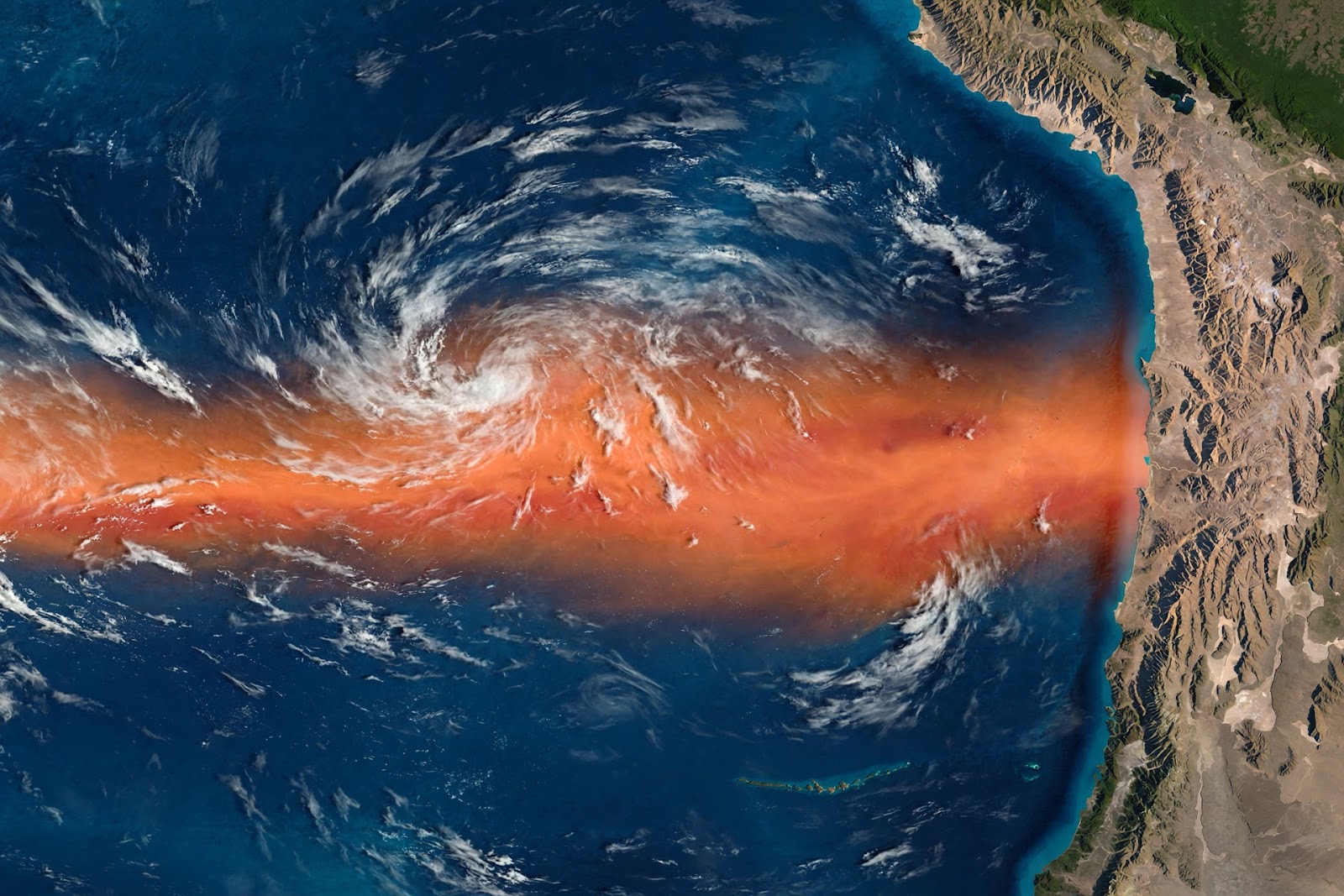
The Pacific Ocean has just done something never seen before in the instrumental record. On 5 October 2026, sea surface temperatures in the Niño 3.4 region — the patch of the equatorial Pacific meteorologists watch most closely — crossed 30°C for the first time ever. That reading, months before the event is expected to peak, has turned the 2026 El Niño from a forecast into a flashing red light — and climate watchers are reaching for a rare phrase: "super El Niño."
In its monthly climate update on 8 October, the World Meteorological Organization said El Niño is "firmly established and strengthening rapidly," with a near-100 per cent chance it persists through February 2027 and a real possibility it becomes one of the strongest events since records began in 1950. This article explains what the record means, how El Niño works, what past super events did — and what this one could mean for your food prices, your weather, and your health.
The record that shocked climate scientists
To grasp the scale, compare two numbers. The new one: a preliminary 30.06°C daily average on 5 October — about 3.4°C above normal for early October, when 26.7°C is typical. The old one: 29.82°C, set on 17 November 2015 during the historic 2015–16 El Niño. The 2026 event beat it in early October, weeks before El Niños typically reach their strength — and the old record itself was set near a peak.
What matters for the atmosphere is the anomaly. The WMO traced the build-up from +1.6°C in June to +2.5°C in August, and forecasts the October–December average at about +3.7°C — shattering the previous seasonal record of +2.6°C from 2015–16. The US Climate Prediction Center has seen anomalies topping +4°C in parts of the eastern equatorial Pacific, and puts the odds of a strong-to-very-strong event lasting through March 2027 at above 83 per cent.
As WMO Secretary-General Celeste Saulo told the Global Heat Forum in Bangkok, El Niño does not create new heat for the planet — it releases heat the ocean has already been storing beneath the surface. This time, she noted, the ocean it is drawing from is the warmest ever measured, so there is simply more heat available to release. The outlook is a consensus across thirteen national and international climate centres, built on ocean buoys, satellites and weather balloons.
What is El Niño, exactly?
El Niño is the warm phase of a natural climate cycle called the El Niño–Southern Oscillation, or ENSO, which flips between warm (El Niño), cool (La Niña) and neutral states every two to seven years. Normally, trade winds push warm surface water toward Asia, fuelling rain over the western Pacific, while cold, nutrient-rich water wells up along South America's coast, feeding some of the world's richest fisheries.
Every so often the trade winds weaken. Warm water sloshes back east toward the Americas, cold upwelling slows, and the tropical weather engine shifts with it. Rain that normally falls on Indonesia and Australia moves out over the central Pacific, leaving Southeast Asia dry while storms pound the Americas' west coast. That chain reaction of winds, rain and pressure around the planet — called teleconnections — is El Niño.
Most events are weak or moderate. Roughly once or twice a generation, anomalies pass about +2.0°C and scientists reach for the informal but fearsome label: super El Niño. Before 2026, the club had three members — 1982–83, 1997–98 and 2015–16 — and each scarred the global economy, food supplies and human lives.

What past super El Niños did to the world
The 1997–98 event remains the benchmark for devastation: tens of thousands of deaths and tens of billions of dollars in damage. Drought parched Indonesia, fuelling runaway fires; floods drowned towns on the Peruvian and Ecuadorian coasts; East Africa flooded while Southern Africa's maize withered — and Peru's anchovy fishery collapsed as the cold upwelling vanished.
The 2015–16 event helped make 2016 the hottest year on record at the time, hammering Southern Africa and Southeast Asia with drought and bleaching coral reefs across the tropics. The 1982–83 event was so strange it was barely detected until it was nearly over — and it launched modern El Niño science. The lesson of all three is the same: the ocean temperature is only the beginning. The damage comes from what the atmosphere does with that heat — and it does opposite things in different places at the same time.
A super El Niño of droughts and floods
That is exactly what is unfolding now. In Papua New Guinea, water sources are drying up, crops are failing and food prices are rising — months before the expected peak. The government set up a special task force with a 112-million-dollar emergency budget; roughly 1.2 million people need immediate food assistance, and the worst agricultural impacts are expected around November.
UNICEF warns the stakes are continental: more than 347 million children in nearly 100 countries and territories face unusually wet or dry conditions between October and December 2026, about 190 million of them in Asia and the Pacific. Colombia, Fiji, Papua New Guinea and the Philippines are expected to run drier — bringing drought, water scarcity, displacement and worsening malnutrition — while the Greater Horn of Africa faces flash flooding that spreads water-borne diseases and closes schools. In crisis-hit countries like Afghanistan and Chad, UNICEF says El Niño can become a direct threat to survival.
Food is where most families will feel it first. The Asian Development Bank warned that a very strong El Niño could push food prices higher across developing Asia — palm oil, sugar and rice are among the most exposed commodities — and, combined with energy-market disruption, could cut 2027 regional growth by 0.44 percentage points while lifting inflation by 0.91 points. Across Latin America, the World Food Programme expects shrinking yields of corn, beans, rice, cocoa and coffee to raise prices — in a region where a healthy diet already costs nearly five dollars per person per day, the most expensive in the world. The Philippines' weather agency, PAGASA, has meanwhile reported the event already strong and expected to intensify into a very strong El Niño through December and possibly into mid-2027.
Health risks run alongside the weather: extreme heat strains hearts and lungs, especially for outdoor workers and the elderly; shifting rainfall spreads mosquito-borne diseases like dengue and malaria into new areas, while floods bring cholera and other water-borne illnesses; drought-driven wildfires choke the air with smoke. Displacement, crop failure and school closures ripple into mental health, child nutrition and household finances for years.

The climate change connection
Is this climate change? The honest answer has two parts. First, El Niño itself is natural — it happened long before the industrial era. Climate change did not invent it.
Second, climate change is loading the dice. The greenhouse effect — the trapping of heat by carbon dioxide and other gases, explained in our primer on the greenhouse effect and how it is warming the planet — has pushed ocean temperatures to the highest levels ever measured. A super El Niño fed by a record-warm ocean releases far more heat into the atmosphere than one fed by a cooler ocean. Scientists are still studying whether a warming world makes El Niños stronger or more frequent — the evidence is not settled — but the physics is clear: whatever El Niño does, it now does it on top of a warmer baseline, and the extremes get more extreme.
Coastal communities face a double threat: warmer oceans expand and gain meltwater, so storm surges arrive on seas that are already higher — read how rising sea levels are already reshaping coastlines.
How communities can prepare
The good news: El Niño is one of the most predictable climate hazards on Earth. We can see it coming months ahead — which means preparation is possible, and it works. UNICEF notes every dollar in disaster risk reduction can save up to fifteen in recovery costs, yet less than one per cent of humanitarian funding goes to anticipatory action. Here is what preparation looks like, from governments to households.
Early warning and planning. Seasonal forecasts give governments months of lead time — Papua New Guinea's task force and emergency budget are exactly the model. Farmers can shift planting dates or switch to drought-tolerant varieties; water utilities can ration before reservoirs run low.
Water, the first battlefield. In drought-prone regions: rainwater harvesting, groundwater recharge and fixing leaky pipes. In flood-prone ones: clearing drains, reinforcing riverbanks and protecting wells from contamination.
Food buffers. Governments can build strategic grain reserves, arrange early food aid for the most exposed, and support smallholder farmers — the backbone of food supply in much of the world — with seeds, credit and insurance. Households can store staples.
Health systems on alert. Clinics in flood zones should stock oral rehydration salts and water-treatment supplies; step up dengue and malaria surveillance; and roll out heat-action plans — shade, water stations, adjusted work hours.
Long-term: cut the warming. Future super El Niños will draw on oceans made warmer by today's emissions. Building clean energy is climate action with direct disaster-reduction value — see our guide to renewable energy sources.
What to watch next
The WMO expects the event to keep strengthening into December, with peak anomalies around year-end and lingering effects well into 2027 — above-average temperatures across much of the globe, and rainfall patterns disrupted in both directions: more droughts in some regions, more floods in others.
The Pacific has broken its record. El Niño gives us something rare in climate disasters: time. The question is whether governments, farmers, health systems and households act on the warning before the peak arrives — because a super El Niño that looks beautiful from space as a glowing band of orange water is only beautiful until it reaches your farm, your coast, or your dinner table.
Sources: WMO Global Seasonal Climate Update (8 Oct 2026); NOAA OISST via Climate Reanalyzer; US Climate Prediction Center October 2026 ENSO update; UNICEF El Niño analysis (Oct 2026); Asian Development Bank September 2026 Outlook; World Food Programme briefing via Global Voices (Oct 2026).